


Beschreibung von Pix4Dcapture
Pix4Dcapture turns your consumer drone into a professional drone mapping tool. A free companion to Pix4D photogrammetry software, Pix4Dcapture is the perfect tool to automatically capture image data - RGB, thermal - for optimal 3D models and maps. Process post-flight images easily on the cloud or desktop applications, producing georeferenced maps and models that are tailored to many industry needs.
Currently, the app supports and was tested for the following drones:
• DJI
- Phantom 4 Pro v2.0
- Phantom 4 Pro
- Phantom 4
- Mavic 2 Pro
- Mavic Pro
- Mavic Air
- Matrice 200
- Matrice 210
- Matrice 210 RTK
- Inspire 2
- Inspire 1 (Pro)
- Phantom 3 Professional
- Phantom 3 Advanced
- Phantom 3 Standard
- Matrice 100
- Spark
• Parrot
- Anafi with Skycontroller 3
- Anafi Thermal with Skycontroller 3 (RGB + Thermal Images)
- Bluegrass with Skycontroller 2
- Bebop 2 with Skycontroller 2
• Yuneec
- H520 with E90 camera and ST16S controller (compatible version available from support page)
Features and benefits:
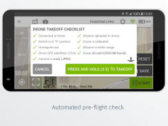
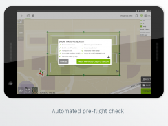
- Fully automated drone mapping
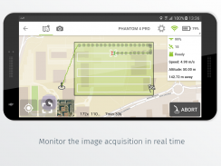
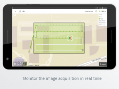
- Drone telemetry and camera live feed during the image acquisition
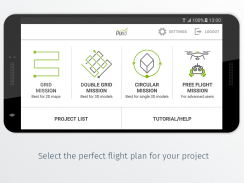
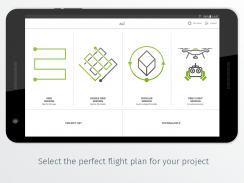
- Different flight plans for different needs
- Polygon Mission for general mapping
- Grid Mission for general mapping
- Double Grid Mission for better 3D model reconstruction
- Circular Mission for point-of-interest 3D model reconstruction
- Free Flight Mission for vertical object mapping with manual flight control
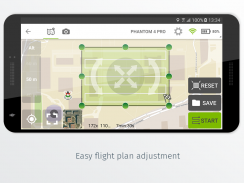
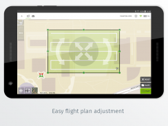
- Flight parameters for each mission - front & side image overlap, camera angle, altitude,
flight speed - can be adjusted based on the requirements of the area.
- Save or duplicate missions to fly the same area of interest several times
- Combine several missions into one project in the project manager
- Precise mission planning by importing KML/KMZ files
- Store the basemap with your flight plan using offline maps
- Change street/satellite basemap provider
- Seamless workflow with Pix4D’s processing software
- Automated image transfer from drone-to-device
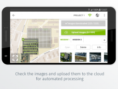
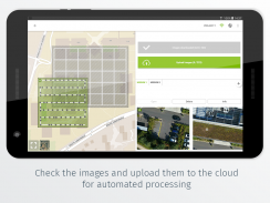
- Upload images directly from the device to Pix4D software in the cloud for processing (license required)
Post-flight processing & analysis using Pix4D’s software on cloud or desktop:
- Achieve survey-grade results from lightweight and compact cameras to large-frame metric cameras
- Usage of Ground Control Points (GCPs) for improving the relative and absolute accuracy of the model
- Generate and modify
- Point clouds
- Orthomosaics
- Digital elevation models (DSM/DTM)
- Index maps (e.g. NDVI)
- And more
- Measure distances, surfaces, and volumes
Important information:
Ensure you have the latest firmware installed on your drone and the app is up to date. The app follows the flight plan and does not avoid obstacles automatically. Pix4D accepts no liability for damage, injuries or legalities from the misuse of this app. Use only in safe environments.
Pix4Dcapture verwandelt Ihre Consumer-Drohne in ein professionelles Drohnen-Mapping-Tool. Pix4Dcapture ist ein kostenloser Begleiter der Pix4D-Fotogrammetriesoftware und das perfekte Tool zur automatischen Erfassung von Bilddaten (RGB, thermisch) für optimale 3D-Modelle und Karten. Bearbeiten Sie Post-Flight-Bilder einfach in der Cloud oder in Desktop-Anwendungen und erstellen Sie georeferenzierte Karten und Modelle, die auf viele Branchenanforderungen zugeschnitten sind.
Derzeit unterstützt die App die folgenden Drohnen und wurde auf diese getestet:
• DJI
- Phantom 4 Pro v2.0
- Phantom 4 Pro
Phantom 4
- Mavic 2 Pro
- Mavic Pro
- Mavic Air
Matrice 200
- Matrize 210
Matrice 210 RTK
- Inspire 2
& nbsp; - Inspire 1 (Pro)
- Phantom 3 Professional
- Phantom 3 Advanced
- Phantom 3 Standard
& nbsp; - Matrize 100
- Funke
• Papagei
- Anafi mit Skycontroller 3
- Anafi Thermal mit Skycontroller 3 (RGB + Wärmebilder)
Bluegrass mit Skycontroller 2
- Bebop 2 mit Skycontroller 2
• Yuneec
- H520 mit E90-Kamera und ST16S-Controller (kompatible Version auf der Support-Seite erhältlich)
Funktionen und Vorteile:
- Vollautomatisches Drohnen-Mapping
- Drohnentelemetrie und Kamera-Live-Feed während der Bildaufnahme
- Unterschiedliche Flugpläne für unterschiedliche Bedürfnisse
& nbsp; & nbsp; - Polygon-Mission für die allgemeine Zuordnung
& nbsp; & nbsp; - Grid Mission für die allgemeine Zuordnung
& nbsp; & nbsp; - Double Grid Mission für eine bessere 3D-Modellrekonstruktion
& nbsp; & nbsp; - Circular Mission für die 3D-Modellrekonstruktion von Sonderzielen
& nbsp; & nbsp; - Freiflugmission für vertikale Objektzuordnung mit manueller Flugsteuerung
- Flugparameter für jede Mission - Front & amp; Seiten- bildüberlappung , Kamerawinkel , Höhe ,
& nbsp; & nbsp; & nbsp; & nbsp; & nbsp; Fluggeschwindigkeit - kann basierend auf den Anforderungen des Gebiets angepasst werden.
& nbsp; & nbsp; & nbsp; - Speichern oder Duplizieren von Missionen, um dasselbe Gebiet mehrmals zu fliegen
& nbsp; & nbsp; & nbsp; - Kombinieren Sie im Projektmanager mehrere Missionen zu einem Projekt
& nbsp; & nbsp; & nbsp; - Präzise Missionsplanung durch Importieren von KML / KMZ -Dateien
& nbsp; & nbsp; & nbsp; - Speichern Sie die Grundkarte mit Ihrem Flugplan mithilfe von Offline-Karten
& nbsp; & nbsp; & nbsp; - Ändern Sie den Straßen- / Satelliten-Grundkartenanbieter
& nbsp; & nbsp; - Nahtloser Workflow mit der Verarbeitungssoftware von Pix4D
& nbsp; & nbsp; & nbsp; & nbsp; - Automatisierte Bildübertragung von Drohne zu Gerät
& nbsp; & nbsp; & nbsp; & nbsp; - Hochladen von Bildern direkt vom Gerät zur Verarbeitung in die Pix4D-Software in der Cloud (Lizenz erforderlich)
Verarbeitung nach dem Flug & amp; Analyse mit der Pix4D-Software in der Cloud oder auf dem Desktop:
& nbsp; - Erzielen Sie Umfrageergebnisse von leichten und kompakten Kameras bis hin zu metrischen Großformatkameras
- Verwendung von Bodenkontrollpunkten zur Verbesserung der relativen und absoluten Genauigkeit des Modells
& nbsp; - Generieren und ändern
& nbsp; & nbsp; - Punktwolken
& nbsp; & nbsp; - Orthomosaics
& nbsp; & nbsp; - Digitale Höhenmodelle (DSM / DTM)
& nbsp; & nbsp; - Indexkarten (z. B. NDVI)
- und mehr
& nbsp; - Messen Sie Abstände , Oberflächen und Volumina
Wichtige Informationen:
Stellen Sie sicher, dass Sie die neueste Firmware auf Ihrer Drohne installiert haben und die App auf dem neuesten Stand ist. Die App folgt dem Flugplan und umgeht Hindernisse nicht automatisch. Pix4D übernimmt keine Haftung für Schäden, Verletzungen oder Rechtsverletzungen, die durch den Missbrauch dieser App entstehen. Nur in sicheren Umgebungen verwenden.
Pix4Dcapture – Version 4.11.0
(13-07-2021)Pix4Dcapture – APK Informationen
APK Version: 4.11.0Paket: com.pix4d.pix4dmapperApps in derselben Kategorie
Das könnte dir auch gefallen...


